Best Hiking Trails and Walks in Malta and Gozo
Last Updated: Jun 26, 2023
Reading Time: 10 minutes
By: Shaun
Are you ready to explore the stunning natural beauty of Malta and Gozo? The islands rugged coastline, hills, and valleys offer a unique opportunity for hikers and outdoor enthusiasts.
Whether you are an experienced hiker or a beginner, the Maltese Islands have plenty of trails to offer. In this article, we’ll take you on a journey to explore the best hiking trails in Malta and Gozo. So, put on your hiking boots and let’s get started!
Best Hiking Trails in Malta and Gozo: A Quick Overview
Before we dive into the details, let’s take a quick look at some of the best hiking trails in Malta and Gozo:
- Victoria Lines
- Dingli Cliffs to Blue Grotto
- Mġarr, Ġnejna, Fomm ir-Riħ and Binġemma
- Golden Bay to Ġnejna
- Miġra l-Ferħa to Blata tal-Melħ
- Il-Kalanka to Ras il-Fenek
- Wied Babu
- Selmun and Mistra
- The Gozo Costal Walk
- Ramla Bay, Calypso Cave and Ix-Xtajta
- Mġarr ix-Xini to Xlendi Bay
- Marsalforn to Wied il-Għasri
- Dwejra to Wied il-Mielaħ
- Comino
These trails offer a range of experiences, from coastal walks to steep climbs, from easy strolls to challenging treks. So, there is something for everyone.
What are the Best Hiking Trails in Malta?
For centuries, the main settlements in Malta were mostly located in the eastern area of the island. This area provided easy access to the sea, and these settlements have gradually grown into the towns and villages one finds today. Luckily, the western side of the island was not affected to the same degree by modern development, which left a lot of space where one could enjoy nature.
The following are some of our favourite treks and walks you can do on the islands of Malta:
1. Victoria Lines
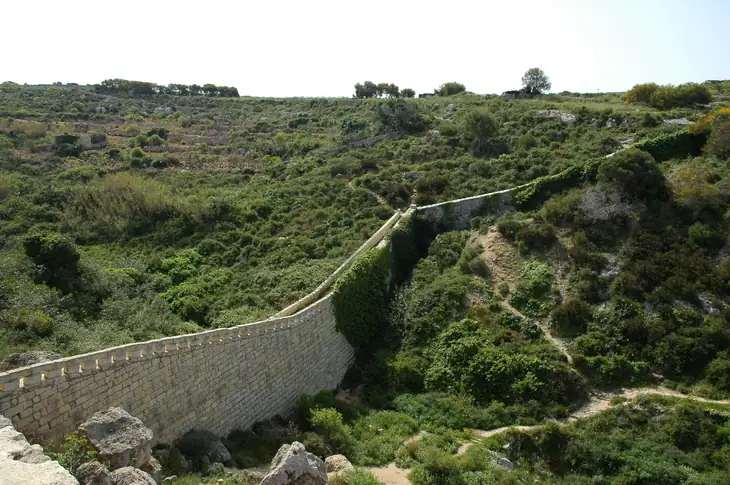
Victoria Lines right on the boundry between Mġarr and Rabat | Image by Rolf Krahl on Wikimedia Commons
The Victoria Lines, built in the late 19th century, are a series of fortifications that run on top of a natural fault line that crosses the island from Madliena to Fomm ir-Riħ, dividing the island two.
The best part of the trek is along the western side of the fortifications, starting from the area known as il-Kuncizzjoni and walk your way to Mosta. The trek is about 10 kilometres long and is suitable for experienced hikers as some parts involve steep climbs and descents, while others have been overgrown with vegetation along the way.
2. Dingli Cliffs to Blue Grotto
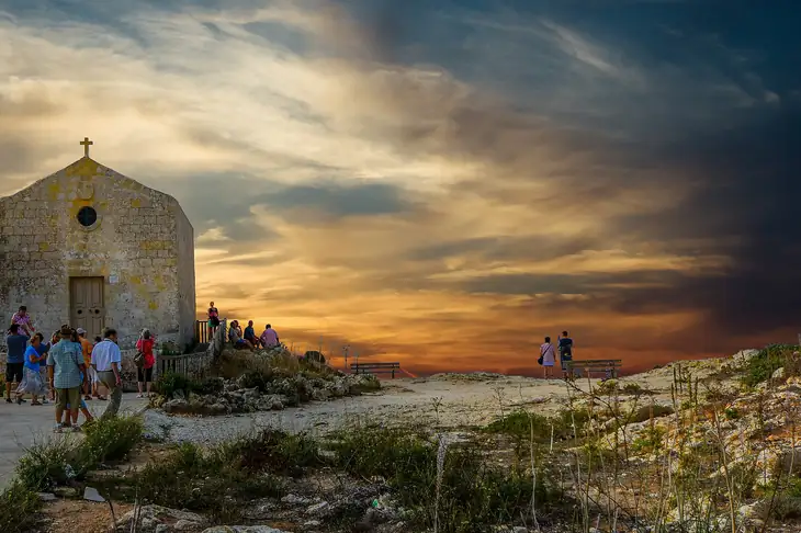
Church Of St Mary Magdalen at Dingli Cliffs | Image by user32212 from Pixabay
The Dingli Cliffs are located on the western side of Malta and are the highest cliffs you can find on the island, with their highest point reaching an elevation of over 250 metres. From the Dingli Cliffs, one can walk about 12 kilometres south to reach the area around the Blue Grotto in Żurrieq.
Along this path, you will encounter some traditional Maltese farms, the famous Chapel of St. Mary Magdalene, and amazing views of the Mediterranean sea and the island of Filfla.
3. Mġarr, Ġnejna, Fomm ir-Riħ and Binġemma
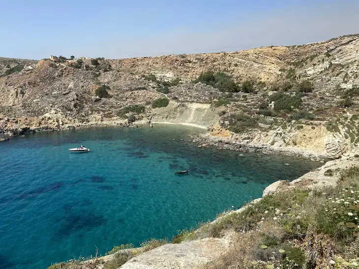
Fomm ir-Riħ | Image by MauiLizard on Wikimedia Commons
Mġarr is a town in the west of Malta that is very popular with the Maltese for the many restaurants that serve traditional Maltese food like rabbit and horse meat. However, around Mġarr, there are some great opportunities to admire the natural landspace of Malta.
Starting from the centre of Mġarr, near the church, you walk towards the coast to the popular beach of Ġnejna before turning south to Fomm ir-Riħ, then turning inland to the small village of Binġemma before returning to the starting point in Mġarr.
This trek is about 10 kilometres long, not too difficult, and definitely worth the effort.
4. Golden Bay to Ġnejna

Steps down to Għajn Tuffieħa | Image by Freddyolsson on Wikimedia Commons
The area around Mġarr is home to a number of popular beaches in Malta, and you can visit these beaches with a short 3-kilometre walk from Golden Bay to Ġnejna, passing by Riveria Beach, or as it is known in Maltese, Għajn Tuffieħa. One can take a detour once past Riveria Beach to Il-Qarraba before proceeding to the Ta’ Lippija Tower and finishing at Ġnejna.
One can extend this trek to start (or finish) at the beautiful Ras il-Waħx, north of Golden Bay.
5. Miġra l-Ferħa to Blata tal-Melħ

View off cliffs of Bahrija | Image by Amante Darmanin on Flickr
Another wonderful cliff trek you can do on the western coast line of Malta is from the Miġra l-Ferħa to Blata tal-Melħ. You can easily get to Miġra l-Ferħa by car and then walk north along the cliffs till you get to Blata tal-Melħ (salty rock).
The trek is about 3.5 kilometres long and takes you along some of the most suggestive cliffs you can find on the islands. You can proceed a bit further north, where you can get to Fomm ir-Riħ beach.
6. Il-Kalanka to Ras il-Fenek
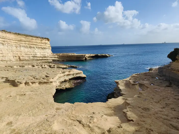
St. Peter's Pool | Image by Giuseppe Milo on Wikimedia Commons
The Delimara penniusla, in the south-easternmost part of Malta, is a hidden gem that is often overlooked by visitors to the islands. The area has a number of coves, which are off the beaten path but definitely worth the effort.
Starting at the georgeous cove at the tip of the pennisula known as il-Kalanka, you can park at the nearby car park and then start your walk along the eastern side of the penniusla to the Knights Battery, then to St. Peter’s Pool, and then walking round the bay known as il-Ħofra Iz-Zgħira (the small hole in Maltese), finishing off at Ras Il-Fenek. Ras Il-Fenek means “head of the rabbit” in Maltese and takes its name from the resemblance the rocks have to a rabbit’s head.
The trek is about 3.5 kilometres long, and you can extend it to go around the adjacent cove of il-Ħofra Il-Kbira (the big hole), but remember you need to make it all the way back to il-Kalanka.
7. Wied Babu

Wied Babu | Image by Frank Vincentz on Wikimedia Commons
Wied Babu is a valley located in the southwestern part of Malta, between the towns of Żurrieq and Qrendi. This valley is another hidden gem of Malta and is popular with local hiking and rock climbing enthusiasts.
The treks at Wied Babu are mostly suited for more advanced and experienced hikers as they involve steep climbs and descents, so if you are looking for a tranquil walk in nature, you would be better off choosing another option on this list.
8. Selmun and Mistra

St Paul's Islands | Image by Amante Darmanin on Flickr
Our last pick takes us to the north of Malta, to Selmun. The trek starts at Selmun Palace, which was built by the Knights of St. John in 1783, and walk to Għajn Ħadid Tower. You do need to get off the road to get all the way to the tower, but it’s worth the effort, as you also get a great view of Imġiebaħ Bay.
Eventually, you need to go back about half the way to take a different road to get to the remains of Fort Campbell, which was used as a battery station during World War II. From Fort Campbell, you can walk all the way down to the coast to il-Blata il-Bajda (white rock), where you get amazing views of St. Paul’s Islands. You should then proceed south to the Mistra Battery and eventually to Mistra Beach. Finally, you can return to Selmun Palace from Mistra Bay.
The loop is around 5.5 kilometres, and parts of the trek require you to walk on an uneven surface. The last kilometre from Mistra Bay to Selmun Palace is mostly uphill, but this trek is an amazing way to get a great view of St. Paul’s islands and surrounding countryside.
What are the Best Hiking Trails in Gozo?
Malta’s sister island, Gozo, too, provides some great opportunities for trekking or just a leisurely stroll. As Gozo is much less densely populated than Malta, it is much easier to find a spot for a nice stroll.
Let’s go through our favourite treks and walks in Gozo.
1. The Gozo Costal Walk

Sunset in Gozo | Image by Michael Camilleri on Flickr
If you are on the adventurous side and want to experience the Gozo countryside to its fullest, then the Gozo Costal Walk is for you. This multi-day, 50-kilometre trek takes you all the way around the island and gives you all that Gozo has to offer, from picturesque sea creeks to tranquil countryside and historic temples and chapels.
If you are interested in knowing more, check out the guide provided by the Visit Gozo website.
If this ordeal is not for you, the next options will be more suited for you.
2. Ramla Bay, Calypso Cave and Ix-Xtajta
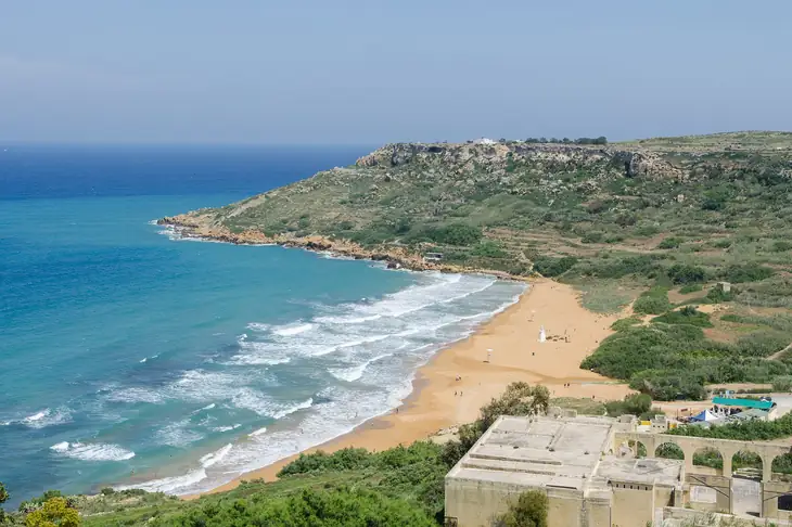
Ramla Bay | Image by DXR on Wikimedia Commons
Ramla Bay is the largest beach on Gozo, and from there, one can trek about a kilometre to Calypso Cave. The cave is named after Calypso, who in Homer’s epic adventure, The Odyssey, lived here and entertained Odysseus during his stay in the cave. Walking down back to the beach, one can then take a path to Ix-Xtajta (meaning small beach), one of the many hidden gems on the island of Gozo.
The walk is quite short at around 1.5 kilometres, but it does require an uphill walk to get to Calypso Cave. The effort would be well rewarded with an amazing view of the beach.
3. Mġarr ix-Xini to Xlendi Bay
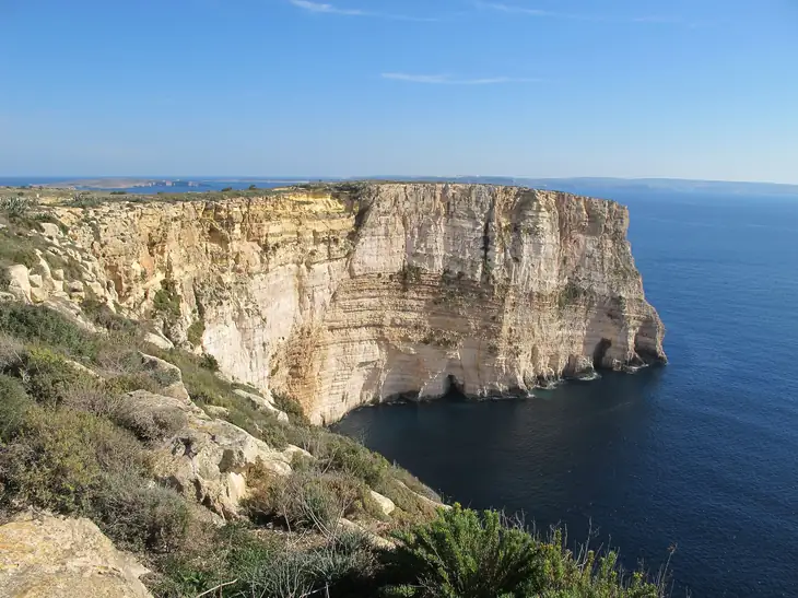
Ġgantija | Image by Kritzolina on Wikimedia Commons
Moving now to the south coast of Gozo, we can take a great walk starting from Mġarr ix-Xini to Xlendi Bay. Between these two popular beaches, one can walk along the impressive Ta’ Cenc Cliffs and Sanap Cliffs.
The walk is around 8 kilometres, and while most of it can be done on the marked footpaths, there will be places where you would need to get off the path to get a short cut.
4. Marsalforn to Wied il-Għasri

Wied il-Għasri | Image by Benjamin Gamblin on Flickr
Another great walk, this time more at sea level, is the path from Marsalforn to Wied il-Ghasri. Marsalforn is one of Gozo’s most popular seaside towns, and one can start walking west along the coast to first get to the area known as Qbajjar, then proceed to il-Qolla il-Bajda before continuing to Xwejni Bay.
Continuing further west, you will then get to Reqqa Point and Għar ir-Riħ, two popular diving spots in Gozo, until you finally arrive at the beautiful cove of Wied il-Għasri.
This walk is 4 kilometres long and is mostly along the road, so it’s an easy leisure stroll.
5. Dwejra to Wied il-Mielaħ

Wied il-Mielaħ | Image by Ruben Holthuijsen on Flickr
Dwejra once housed the famous Azure Window, which was one of Malta’s most famous and recognised landmarks. Unfortunately, the limestone arch was destroyed in a storm in 2017, and since then, the less known arch at Wied il-Mielaħ has filled the void left by the Azure window.
This trek is a bit off the beaten path with no path clearly indicated, but one can start from Dwejra and trek north along the coast past the Mushroom Rock, and eventually you get to Wied il-Mielaħ.
You don’t need to take this path to visit Wied il-Mielaħ, but it will give you some amazing views of the sea and pass you through probably the most rural area of Gozo.
6. Comino

Comino | Image by Tristan Reville on Flickr
Our last entry is neither on Malta nor in Gozo, but on the small inhabited island of Comino. Comino is mainly known for the gorgeous Blue Lagoon beach, but from this beach, you can start a 7-kilometre trek that will take you round the many treasures of this small island, like San Nikolaw Bay, Santa Maria Bay, St. Mary’s Battery and Tower, and Crystal Beach, before returning to the Blue Lagoon.
Please note that as Comino is an inhabited island, you will not find many facilities nearby, but a trek around the island is well worth it, especially on a beautiful spring day when the sea is still too cold for a dip.
Comino can be reached by ferry boat from Marfa in Malta or Mġarr in Gozo.
Conclusion
Malta and Gozo may be small islands, but they have plenty to offer hiking enthusiasts or just those who enjoy a walk in the countryside. So while preparing for your visit to Malta, make sure you pack your walking shoes and explore some of the best landscapes the Maltese islands have to offer.
Frequently Asked Questions
Are the hiking trails in Malta well-marked?
Yes, most of the hiking trails in Malta are well-marked, but it is always a good idea to carry a map or a GPS device.
Do I need any special gear for hiking in Malta?
It depends on the trail you choose. For easy walks, you can wear comfortable walking shoes and carry a small backpack with water and snacks. For challenging hikes, it is recommended to wear hiking boots and carry a full backpack with all the necessary gear.
Can I hike alone in Malta?
It is always recommended to hike in a group or with a guide. However, if you choose to hike alone, make sure to inform someone of your plans and carry a communication device.
Is it safe to hike in Malta?
Yes, it is safe to hike in Malta. However, it is always important to take precautions and follow safety guidelines.
What is the best time of the year to hike in Malta?
The best time to hike in Malta is from October to May, when the weather is cooler and more pleasant.
Are there any fees for hiking in Malta?
No, most of the hiking trails in Malta are free to access.


